Broader Terms
- BT projection
Alternative terms
- UF zenithal projection
Related terms
- RT azimuth
- RT map
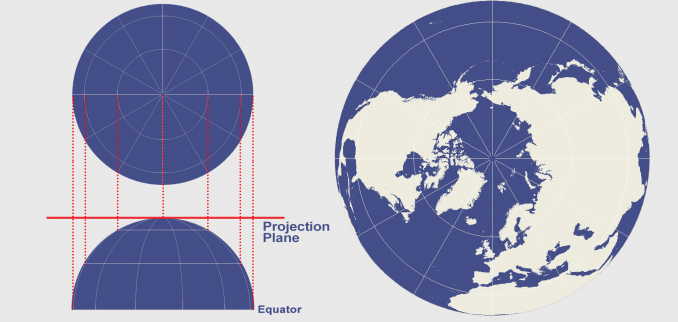
The azimuthal projection plots the surface of Earth using a flat plane. Imagine light rays radiating from a source following straight lines. Those light rays intercept the globe onto a plane at various angles. The light source can be emitted from different positions developing different azimuthal map projections. Some of the common perspective azimuthal projections include gnomonic, stereographic and orthographic.
The azimuthal projection type intercepts the Earth according to laws of perspective, plots the traces of light onto a developable surface. When the source of light is placed in different locations, it affects the geometry of the projection. When polar (normal) projections are the center point of the planar projection surface, it results in meridians as radial straight lines converging at poles. This means that azimuthal projections present true direction (azimuth) from the mapmaker’s center point of choice. Further to this, a property of azimuthal projections is that they have straight geodesics through the map center. This makes azimuthal projections well-suited for maps of the Arctic, Antarctic and hemisphere types of maps.
Whether the plane is tangent (just touching it) or is secant (intersecting it), you can minimze the level of choosing standard lines. The tangent plane has one point of contact (a point of tangency), whereas the secant plane has an entire line of intersection. A secant plane for a polar projection results in a latitude line as a standard line without any distortion. As a result, distortion increases away from point of tangency or secancy.
None of the perspective azimuthal projections can plot out the Earth as a whole, though a non-perspective azimuthal projection can.
https://gisgeography.com/azimuthal-projection-orthographic-stereographic-gnomonic/